Proposals
A vision for a new sustainable community
Sites KB1 and KB2 are intimately connected with each other and with the village of Knebworth as a whole. KB2 will be delivered first to enable the development of the primary school, with KB1 being delivered afterwards.
Vision principles
Well designed, well connected
- Develop a well-designed, 21st-century village that connects proposed neighbourhoods with existing Knebworth communities, drawing inspiration from Knebworth’s heritage as a historic ‘Garden’ community.
- Preserve and connect landscape features, create a central North-South Green Route, and design a focal village green to promote biodiversity, walking, and cycling.
- Implement street design principles rooted in Garden Village traditions, ensuring safe, navigable, and aesthetically aligned streets that encourage healthy living and social cohesion.
- Support walkable spaces and reduce vehicular impact, promoting healthier lifestyles and stronger community connections.
- Utilise natural topography, existing hedges, and water features as focal elements within KB1 and KB2, harmonising with the village layout and connecting the school and residential areas effectively.
Key features
Benefits for the community and the local area
There is significant opportunity with the Strategic Masterplan for the KB1 and KB2 allocations to deliver much needed new homes, green open space, a new school and infrastructure that will benefit both existing and new residents.
- Circa 384 high-quality new homes
- Up to 40% affordable homes with a mix of tenures
- A diverse range of housing options, including apartments and 2 to 5-bedroom houses that have been designed to reflect the local character of Knebworth
- Sustainable design features
- Land for a new Primary School
- New walking and cycling routes
- Biodiversity net gain with new tree planting and preservation of existing natural features
- Contributions to local infrastructure and services
- Enhanced green spaces with a new village green, central open spaces, and improved landscaping
- Connecting with existing village infrastructure, maintaining Knebworth’s historical charm and character
We are dedicated to ensuring that these developments positively contribute to the community and enhance local amenities.

The site
Explore the Strategic Masterplan
The sites are located on the western edge of Knebworth. They are allocated in the North Herts District Council Local Plan 2022 with allocations KB1 & KB2, meaning that residential development is, in principle, acceptable on the sites.
Explore the strategic masterplan below.

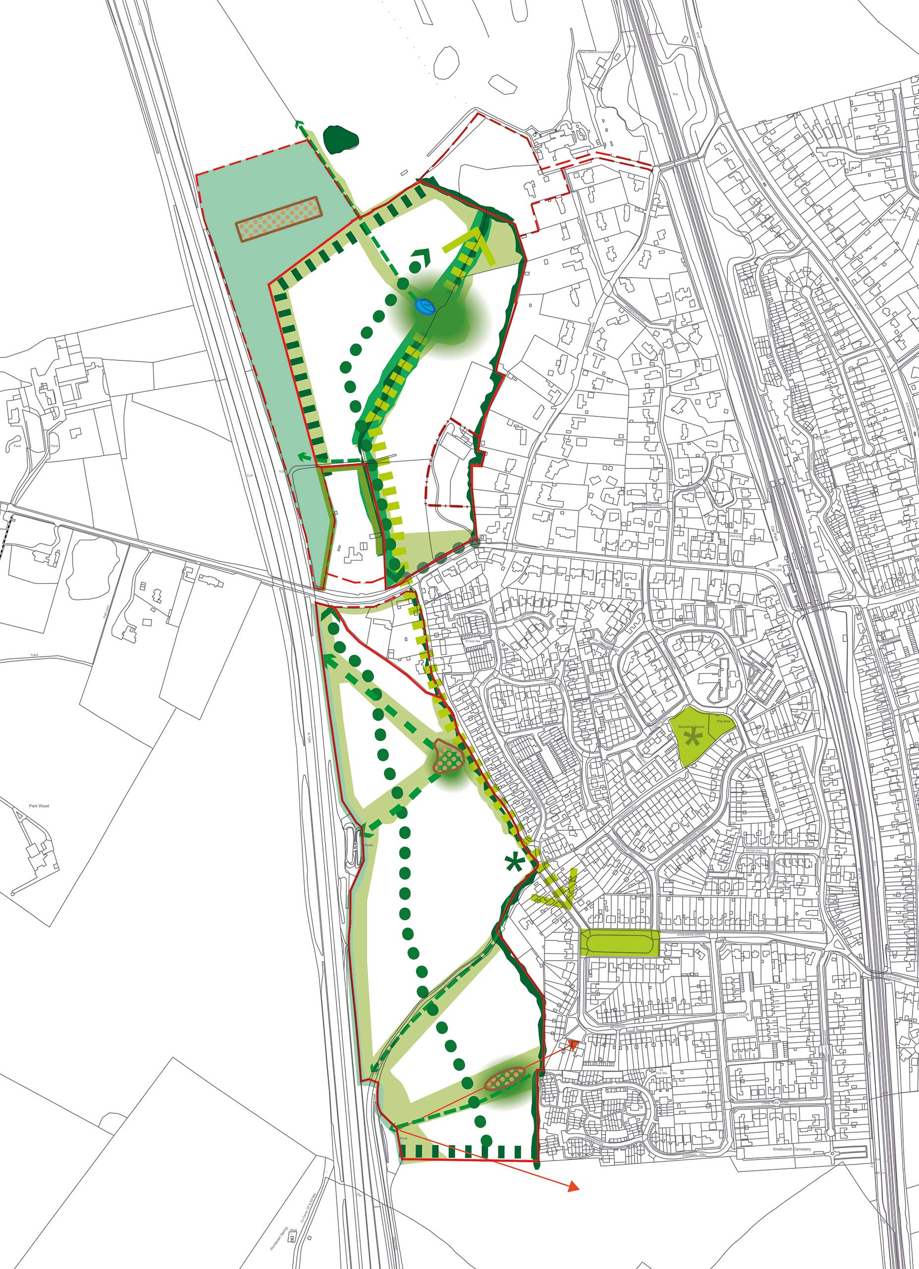
 Village green on Park Lane, gateway to KB1 and active travel link to KB2
 School site
 Gipsy Lane active travel route linking school to KB1
 Active travel routes along old lane from KB2 to Knebworth centre
 Existing Gipsy Lane with reinstated hedgerows
 Area for supporting green infrastructure
 KB1 central open spaces aligned with retained hedgerow, mature trees and pond
 Retained high ecological value grassland
 KB2 valley bottom open spaces
Design
Innovative and sustainable design that is in keeping with local character
The design principles for the Strategic Masterplan have taken inspiration from Knebworth and the surrounding Garden Villages to ensure the rich culture and heritage is continued through the new neighbourhoods.
Building on the Lutyens Masterplan, the layout will prioritise green spaces, including a central village green, and maintain the traditional village feel with carefully planned streets and public spaces. Active travel routes will connect the new neighbourhoods to Knebworth’s station and village centre, promoting walking and cycling while reducing car dependency.
The design will incorporate sustainable features such as energy-efficient buildings and green corridors to enhance biodiversity ensuring the development meets modern needs without compromising the village’s unique charm.
This approach to design reflects the local character and community spirit, with ongoing consultation ensuring that the plans evolve to seek to meet the aspirations of Knebworth’s residents.
Sustainability
A sustainable opportunity to extend the Garden Village and create a new Garden Community
Knebworth has great transport connections, thriving local amenities, and a rich Garden Village heritage, providing an opportunity to deliver sustainable development. The KB1 and KB2 sites are strategically located near Knebworth Station and the A1(M), ensuring convenient access to surrounding areas and London.
Guided by Garden Village principles, the development emphasises walkability, connectivity, and sustainability. Green travel routes will link the new neighbourhoods with Knebworth’s station, village centre, and local amenities, promoting active lifestyles and reducing car dependency.
A network of landscaped public open spaces, including the new school near Stockens Green in KB2, will provide much-needed capacity and add valuable open space to the western side of Knebworth. These green spaces will connect via high-quality north-south active travel routes through the sites, seamlessly integrating with existing footpaths and cycleways in the village.
Both KB1 and KB2 will feature energy-efficient buildings, sustainable drainage strategies, and carefully designed green spaces to enhance ecological value. These sustainable developments, as confirmed in the Local Plan, are well-positioned to support the needs of the community while preserving and enhancing Knebworth’s unique character.

Enhanced connectivity
New footpaths and cycleways linking into Knebworth
For any new development to truly integrate with the existing community, it’s essential to connect both the new and established areas. A comprehensive network of pedestrian and cycle routes will link the new development to Knebworth’s existing infrastructure, including the station and village centre. These connections will allow both new and existing residents to enjoy enhanced public spaces and green areas.
The footpaths and cycleways will connect seamlessly to existing local networks, encouraging active travel, and reducing car dependency. This will improve accessibility for all, including those with limited mobility, ensuring everyone can easily reach key destinations like the Knebworth Station and parks.

Gateway to the development
Access and transport
One of the key principles of this development is the connectivity with Knebworth, providing new and existing residents with enhanced access to facilities and open spaces.
A Transport Assessment will accompany the planning applications, setting out the detailed transport strategy, assessing potential impacts on the local road network, and outlining necessary mitigation measures.
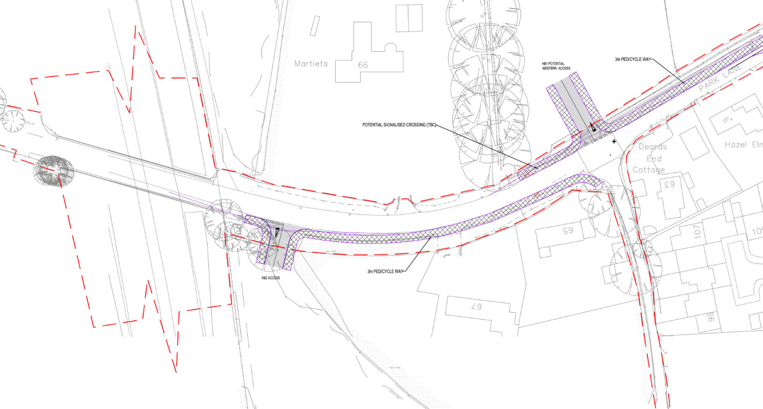
Emphasis is placed on integrating safe pedestrian and cycle routes throughout the development, connecting seamlessly to existing routes to promote sustainable and active travel.
Improvements will include:
- A comprehensive network of pedestrian and cycling paths that prioritises connectivity and safety to encourage active travel, offering direct links to key destinations including Knebworth Station and village centre.
- Proposed connections to primary routes include safe crossings and dedicated lanes, enhancing accessibility for all users, including children and those with limited mobility.
- A Travel Plan will establish strategies to encourage sustainable travel choices, such as car-sharing incentives, secure cycle storage, and improvements in pedestrian access, helping to minimise additional pressures on surrounding roads from the outset.
- Walking and cycling to the nearby village centre and railway station will be encouraged with integrated pedestrian and cycle routes connecting to existing routes.
- The access to the sites has been developed in consultation with the Council and Highways consultants after undertaking a review of options for third-party land inclusions and different junction types including roundabouts.
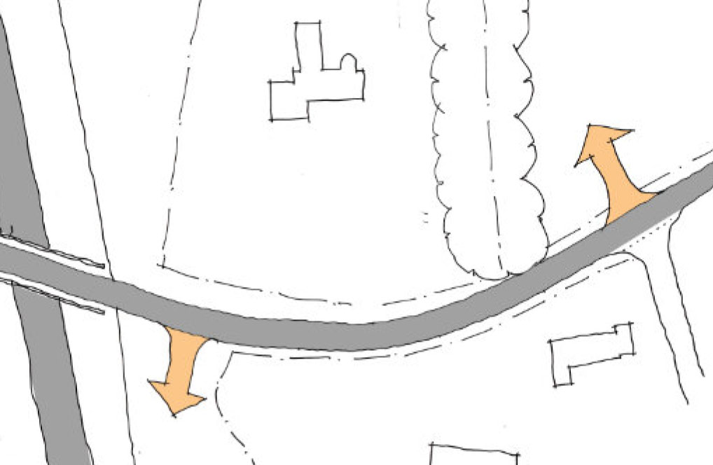
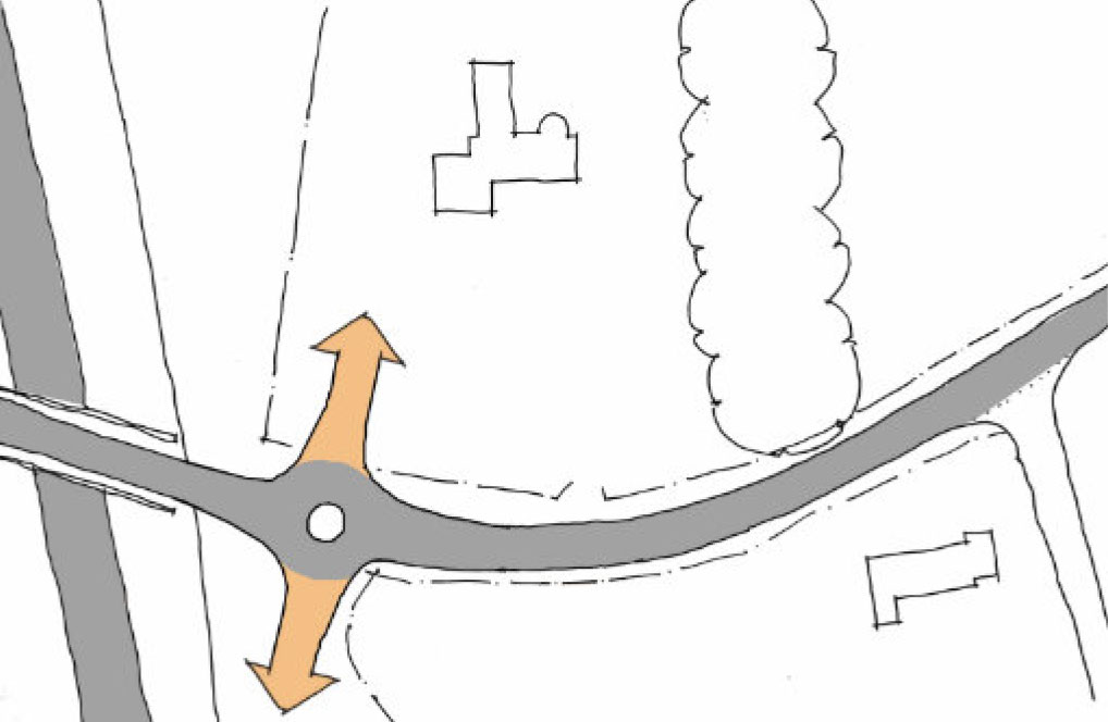
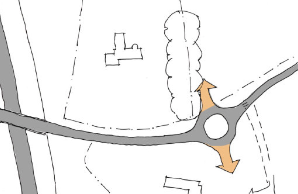
The agreed approach is for a pair of staggered junctions using land within the current ownership.
Landscape and ecology
Creating new open green spaces for all to enjoy
The landscape strategy is designed to preserve existing hedgerows and tree belts within publicly accessible open spaces, creating multi-functional areas that support biodiversity, sustainable drainage, public amenities, and pedestrian and cycle paths.
Both KB1 and KB2 present different typologies when it comes to landscaping and ecology which must be accounted for.
This landscape-led scheme will expand and enrich green spaces, promoting biodiversity and fostering a sense of place for the new and existing Knebworth residents to visit and enjoy.
Key landscaping improvements include:
- Achieving a biodiversity net gain of at least 10%.
- Protecting and enhancing existing areas of ecological value, including established woodlands.
- Establishing green corridors to strengthen local ecosystems.
- Within the layout of housing, amenity green space will be well distributed, enhancing the character of each part of the site and providing incidental amenity spaces.
- Any on-site play provision to be located within identified open spaces, to be an integral part of the development and within accessibility of the future and existing community.

Green infrastructure plan
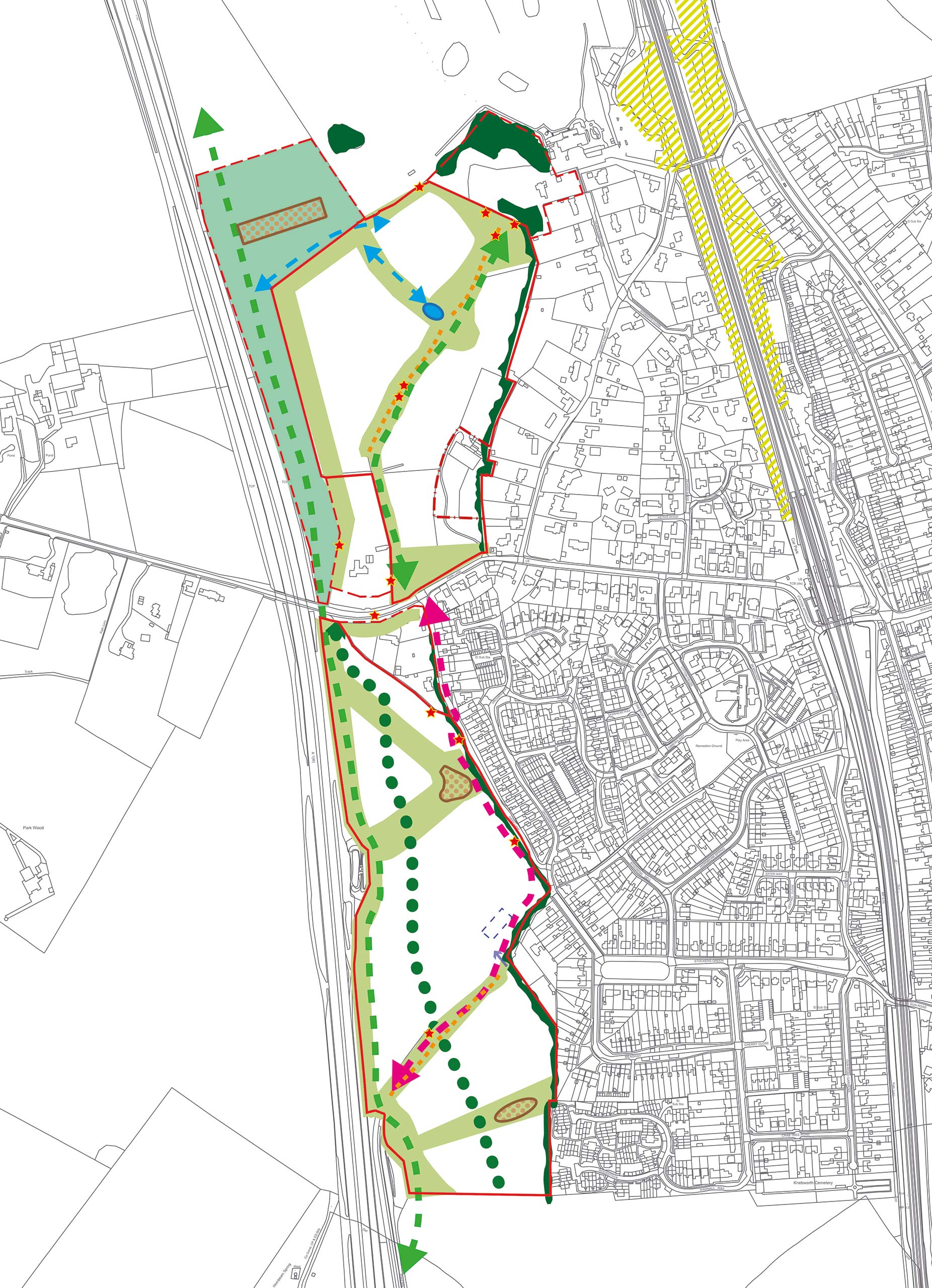
 KB1 and KB2 allocation boundaries
 Potential betterment opportunity outside allocation
 Land within allocation, but not under Countryside control
 Area for supporting green infrastructure
 Existing hedge / copse
 Green link
 Destination point and green backdrop to Stockens Green
 Existing public open space
 Proposed new green central spine
 Defensible green belt boundary
 Location for further open space if required
 Green frontage onto Park Lane
 Potential green spine connection
 Proposed green connections
 Retained boundary planting to “Martlets”
 Attenuation feature
 Pond
Pond Distant view across Knebworth
 Green Avenue connection
 NEAP location / potential for improving existing NEAP
Landscape and biodiversity framework plan
 KB1 and KB2 allocation boundaries
 Potential betterment opportunity outside allocation
 Land within allocation, but not under Countryside control
 Existing tree group or hedge line
 Semi natural green space for supporting green infrastructure
 Green link
 Existing corridor with potential to enhance to priority habitat
 Key potential bat roost trees
 Enhanced green link
 Restored green link
 Created green link
 Important hedgerow retained on site
 Attenuation feature
 Pond
Pond Potential school position (HTA does not have control of design within school boundary)
 Potential access to school site
 Green Avenue connection
FAQs
Your key questions answered
What is a Strategic Masterplan
To ensure the delivery of well-designed quality places that meet local needs, North Herts District Council is committed to a rigorously tested Strategic Masterplanning Process for strategic sites.
The Strategic Masterplan, amongst other things, seeks to achieve the following outcomes:
- The broad distribution of development across the site.
- Setting out the spatial vision early on including links and relationships with existing homes and infrastructure.
- Consultation and involvement with the community.
- Design principles for new buildings and spaces.
As a result, we have set out the framework of the Masterplan Area early on and this includes the links and relationships with existing homes and infrastructure immediately surrounding the site.